Puno, Arequipa, and Bolivia!

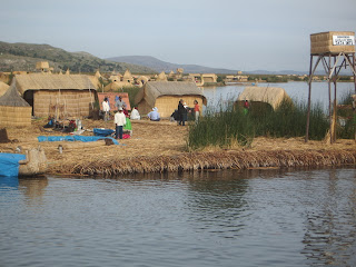 First shot of the floating islands of Uros. The locals actually make these islands by cutting away at the peaty roots of the reeds, tens of meters down. The peat rises to the surface and they "stitch" the pieces together into an island. Each island will last about 12 years, and they need to do maintenance on them 2 times a month.
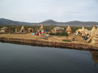 Another shot of one of the floating islands.


 Here I am on Taquile Island. Taquile Island is famous for its knitting work because of its relative isolation from the rest of the Quechua nation. Indeed, their knitting and weaving was the best that I saw in Peru. I bought a Quechua woolen hat for those long cold Canadian winters...
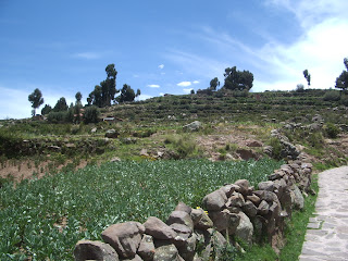 The side of the island. Growing crops of a sort...
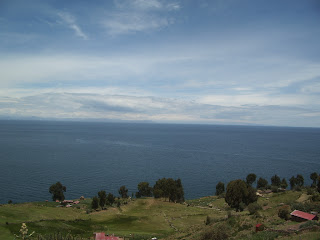 Looking out over Lake Titicaca from Taquile Island.
 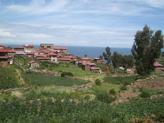 Some of the village houses on the island. Supposedly, there are about 3000 inhabitants on the island, although it hardly seemed possible. The island really is quite small.
Flowers growing on the island in someone´s back yard.
 A shot of Taquile Island as I was leaving.
 Skip some travel time, and here we arrive in Puno. The night I returned from the floating islands, I was ready to take off to Arequipa. However, the tour agency was not available by phone, so I stayed another night. I was really glad that I did, because there was a practice session for the upcoming (now passed) festival of Candelaria. It all began with a solemn procession of the local bishops and priests and then loud marching bands all night long. It was truly amazing. Be sure to check out my videos of it on my YouTube account, "mindputty".
 Ok, skip some more travel time. I arrived in Arequipa and took the trip out to Colca Canyon aboard a bus. While travelling, the scenery changed considerably. At one of the reststops there was this baby alpaca just hanging out. This little fella decided that this green straw was just as good as a nice juicy piece of grass.
 As I mentioned, the scenery from Arequipa to Colca Canyon was quite different from the rest of Peru. Peru really does cover a wide range of geographical types. Everything here was very deserted.
 On the way to Colca Canyon, there were numerous alpacas, llamas, and vicunias (sp?). Here is an oasis where a great herd of alapacas were hanging out and munching on the greenery.
 Is that a pack of llamas? Why, yes it is!
 More llamas.
 A rather astute looking alpaca.
 Here is the cozy town of Chivay nestled in the Andean mountains. We spent the night here.
 A girl feeding her baby alpaca with a milk bottle.
 Here is the town square of Chivay. It had a really Mediterranean feel to it.
 That night, we were treated to a performance by a Peruvian band and dancers to accompany. I know this picture is a little dark. If you click on it to enlarge, you may be able to see it better.
 The dancers, showing a traditional dance narrating the harvesting of potatoes. At one point we were asked to get up and dance with them. Dancing at a high altitude is really difficult.
 Here is a group of dancers in another town that we passed through on the way to Colca Canyon. I didn´t catch the name of the town, unfortunately. The bus stopped for a short time to see the church, the dancers, and an optional picture with various birds of prey.
  Here I am, nearly getting eaten alive by the falcon that perched on my forearm, then arm, then shoulder.
 Surprisingly, the falcon´s grip wasn´t painful at all. I like falcons.
 Here is the church that I mentioned. The various artists who did all the commissions for the churches in Cuzco, Lima, etc. decided to join together and make this church out in the middle of nowhere. Check out the detail!
 Colca Canyon, near the beginning.
 Here, in the middle you can see a large stone with carvings on it. Archaeologists speculate that the drawings are actually a blueprint for the terra-forming that occurred across the canyon to make agricultural plateaus.
 The name of Colca Canyon comes from small nooks that were created on the sides of the mountain by the ancient Andean people. In some cases, the nooks were used to refrigerate crops, and at other times they were used as burial sites, as seen in this pictures. The reddish area in the middle of the picture is near the opening of this burial site. Click to enlarge.
 Colca Canyon.
 A strange plant that was found growing in various places along the mountain.
  If you click to enlarge this photo, you can see a lizard resting on the crest of the rock in the middle of the picture. Colca Canyon and surrounding area really is a desert.
 The majestic condor. I thought it would be really over-hyped, but I really was impressed. With a wingspan of 3 meters and a vertical body height when perched of over 1 meter, this bird is a monster. The condor actually belongs to the vulture family, and has a highly keen sense of smell. When a condor eats carrion, it actually needs to rest for a while before it can fly again.
  Here, you can see that Colca Canyon really is an arid desert. Cactii are everywhere.
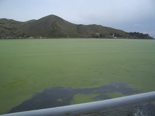
  Fastforward to my voyage to La Paz, Bolivia. Basically, I returned to Arequipa and then took the bus to Puno and then to La Paz. The bus ride took about 19 hours over 2 days. I could have taken a direct 11 hour bus ride to La Paz, but in an effort to save some money, I opted for the former. All in all, I saved about 20 dollars. Whoopee. Then again, that equates to about 3 nights lodging in La Paz... Here is our bus crossing a strait on Lake Titicaca, on a rickety old wooden boat. We were asked to get off and then board again once the boat had crossed. It was nervewracking to watch the boat teeter back and forth.
 Once on the shore, and within the boundaries of Bolivia, there is none other than... Colonel Sanders, of KFC fame, a national hero in Bolivia.
 No, actually, as you can read, this is a statue of Don Eduardo Avaroa. He was a war hero during the War of the Pacific, in which Bolivia and Peru waged war against Chile. Anti-Chilean sentiment lingers today in Peru, Bolivia, and Argentina. During the war, Bolivia lost its coastal border to the Pacific. Eduardo Avaroa fought to the death at a bridge pass when all the Bolivian army had retreated. When asked to surrender by the Chilean army, he cried "Surrender? Your grandmother should surrender, you *****". This statue was very close to the Bolivian city of Copacabana (not the Brazilian Copacabana, mind you).
 Here is the landscape on the way to La Paz, away from Copacabana.
  The valley city of La Paz, Bolivia, as seen from the ridge road leading into the city. Oh, in case you were wondering, (and I know you were) La Paz is the de facto capital city of Bolivia. Sucre is the administrative capital. La Paz is also the highest national capital city in the world.
 Part of the city, looking up from a central square, Alonso de Mendoza.
  Wares for sale in the streets of La Paz.
A statue I saw while on a walking tour of La Paz. I can´t put a name to it right now, but with some reasearch, I will have it for you later.
Well, that pretty much brings me up to date. Last night, I went dancing at a local bar 3 blocks from my hostel with live South American music. It was filled with locals, and myself and an American guy were pretty much the only two gringoes in the place. It was fun though, despite the struggling to breathe in the thin air.
Hope you are enjoying my blog. If you are, please let me know by dropping me a line via e-mail. Knowing you are interested in my pictures and travels is my only reward for putting in the effort!
Also, don´t forget to check out my videos at http://www.youtube.com/user/mindputty !!
Cheers!
posted by Ben Norris at
5:14 p.m.
|
0 comments
![]()